GOZ031 - Ta' Golin
Description
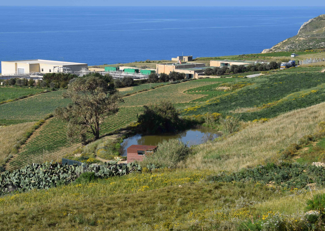
Ta' Ġolin is an artificially constructed pond, located in south-eastern Gozo, within the village of Għajnsielem. The pond covers an approximate area of 1,215m2. The site is accessible from a surfaced road, however, it is located on privately-owned land. The site is predominantly surrounded by agricultural land, however, no pipelines were visible. A bird hide is located close to the pond and therefore it is possible that the pond is being used for hunting activities. Arundo donax and Eucalpytus camaldulensis are present within the site basin. The site is not protected by any legislation.

Wetland data
Basic information
| Wetland location: | Inland |
| Wetland type: | Artificial |
| Wetland area: | 0.10 Ha |
| Hydrological interaction: | - |
| Water salinity: | Fresh (< 0.5 g/l) |
| Type of fresh water input: | Catchment area (precipitation) |
| Surface water runoff | Other |
| Open water area (%): | 26 - 50 |
| Hydroperiod: | Permanent |
Geographic information
| Census district: | Gozo and Comino |
| Island: | Gozo |
| Local council: | Ghajnsielem and Comino |
| Longitude: | 14.279050 East |
| Latitude: | 36.020810 North |
Biological significance
| Biological significance: | Low |
Ramsar wetland type
| Type | Coverage (%) |
| 2 -- Ponds; includes farm ponds, stock ponds, small tanks; (generally below 8 ha) |
Property status
| Private |
Ecosystem services
| Type of ecosystem service | Ecosystem service | Scale of Βenefit (%) | Importance |
| Provisioning services | Food | ||
| Provisioning services | Fresh water | ||
| Cultural services | Recreation and tourism | ||
| Regulatory services | Water regulation |
Activities on wetland
| Activity | Intensity |
| 020 = Resource conservation | High |
| 130 = Irrigation | High |
| 230 = Hunting | High |
| 701 = water pollution | High |
Activities on catchment area
| Activity | Intensity |
| 100 = Cultivation | High |
| 110 = Use of pesticides | High |
| 120 = Fertilisation | High |
| 130 = Irrigation | High |
| 230 = Hunting | High |
| 502 = roads motorways | High |
| 701 = water pollution | High |
Impacts
| Impact | Intensity |
| EB- = Increase in aesthetic qualities | High |
| EE- = Increase of economic potential | High |
| ES- = Increase in water supply | High |
| PF- = Fertilizer/Excess nutrient pollution | High |
| PP- = Pesticide pollution |
Vegetation types
| Type | Coverage (%) |
| Emergent | < 5 |
| Shrubby / Arborescent | < 5 |
| Other | 51 - 75 |
Flora
| Species | Presence status | References |
| Arundo donax | ||
| Eucalyptus sp. |
Images