
MAL017 - Bahar ic-Caghaq
Description
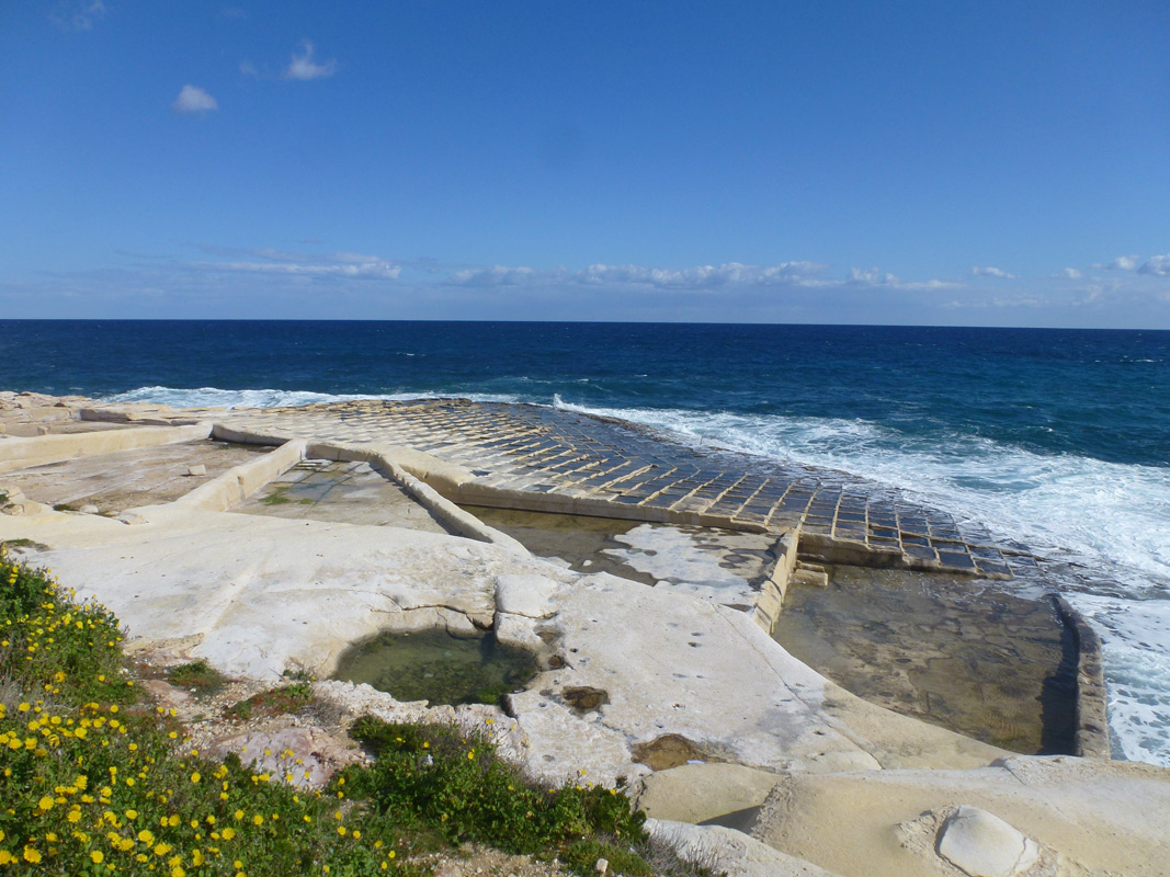
Baħar iċ-Ċagħaq are a series of interconnected salt pans, located in northern Malta within the Limits of Baħar iċ-Ċagħaq. The site is easily accessible to the public from a nearby surfaced road. The salt pans cover an approximate area of 4,150m2. It is unclear whether the salt pans are still being used for salt production. The site is predominantly surrounded by natural coastal habitat. It is also, however, within close proximity to a water park. The basin of the salt pans was dominated by Limbarda crithmoides.
Wetland data
Basic information
| Wetland location: | Marine/Coastal |
| Wetland type: | Artificial |
| Wetland area: | 0.40 Ha |
| Hydrological interaction: | - |
| Water salinity: | Salty (> 18.0 g/l) |
| Type of fresh water input: | Catchment area (precipitation) |
| Surface water runoff | Other |
| Open water area (%): | 76 - 95 |
| Hydroperiod: | Permanent |
Geographic information
| Census district: | Northern |
| Island: | Malta |
| Local council: | In-Naxxar |
| Longitude: | 14.458830 East |
| Latitude: | 35.939970 North |
Biological significance
| Biological significance: | Neutral |
Ramsar wetland type
| Type | Coverage (%) |
| 5 -- Salt exploitation sites; salt pans, salines, etc. |
Property status
| Public |
Activities on wetland
| Activity | Intensity |
| 020 = Resource conservation | High |
| 340 = Salt works | High |
| 690 = Other leisure and tourism impacts | Medium |
| 720 = Trampling overuse | Medium |
| 920 = Drying out | High |
Activities on catchment area
| Activity | Intensity |
| 402 = discontinuous urbanisation | Medium |
| 419 = other industrial / commercial areas | High |
| 502 = roads motorways | High |
| 690 = Other leisure and tourism impacts | Medium |
Impacts
| Impact | Intensity |
| EB- = Increase in aesthetic qualities | High |
| EE- = Increase of economic potential | High |
| EF- = Increase in protection from natural forces | Medium |
| EO- = Increase potential for natural products | Medium |
| EU- = Increase of tourist/recreation potential | High |
Vegetation types
| Type | Coverage (%) |
| Other | |
| Halophytic | < 5 |
Flora
| Species | Presence status | References |
| Carpobrotus edulis | ||
| Jacobaea crithmoides |
Images
