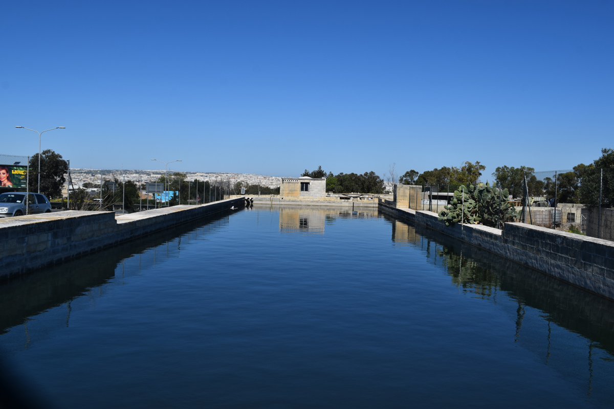
Triq Garibaldi is an artificially constructed reservoir, intended for irrigation, water storage and flood prevention, located in southern Malta within Paola. The reservoir is made of cement and covers an approximate area of 1,160m2. The site is accessible to the public by a surfaced road, however, the reservoir itself is fenced off. The reservoir lies alongside an abandoned building and is close to other buildings to the north and east, while to the west lies a surfaced road and to the south lies active agricultural fields. Numerous culverts are present redirecting water from the road and from nearby fields into the reservoir, and pipelines are visible exiting onto nearby fields indicating that the reservoir is being used for irrigation of these fields. The site is located in a Strategic Open Gap.
Wetland data
Basic information
Wetland location:
Inland
Wetland type:
Artificial
Wetland area:
0.10 Ha
Hydrological interaction:
-
Water salinity:
Fresh (< 0.5 g/l)
Type of fresh water input:
Catchment area (precipitation)
Surface water runoff
Outflow controlled by pipeline
Open water area (%):
> 95
Hydroperiod:
Permanent
Geographic information
Census district:
Southern Harbour
Island:
Malta
Local council:
Paola
Longitude:
14.496230 East
Latitude:
35.863710 North
Biological significance
Biological significance:
Low
Ramsar wetland type
Type
Coverage (%)
6 -- Water storage areas; reservoirs/barrages/dams/impoundments (generally over 8 ha)
Property status
Private
Ecosystem services
Type of ecosystem service
Ecosystem service
Scale of Βenefit (%)
Importance
Provisioning services
Fresh water
Activities on wetland
Activity
Intensity
020 = Resource conservation
High
130 = Irrigation
Low
701 = water pollution
Low
Activities on catchment area
Activity
Intensity
100 = Cultivation
Low
110 = Use of pesticides
Low
120 = Fertilisation
Low
130 = Irrigation
Low
402 = discontinuous urbanisation
Low
430 = Agricultural structures
Medium
440 = Storage of materials
Low
502 = roads motorways
High
701 = water pollution
Low
Impacts
Impact
Intensity
EE- = Increase of economic potential
High
ES- = Increase in water supply
Low
PF- = Fertilizer/Excess nutrient pollution
Low
PP- = Pesticide pollution
Vegetation types
Type
Coverage (%)
Other
< 5
Images
Nature Trust Malta. (2019). MtIsWet – Database of the Maltese Islands Wetlands. Updated: 04.2024