MAL082 - Il-Ballut ta' Marsaxlokk
Description
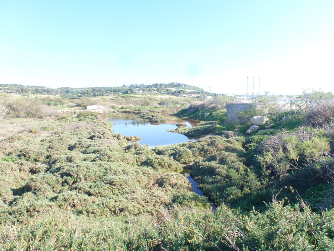
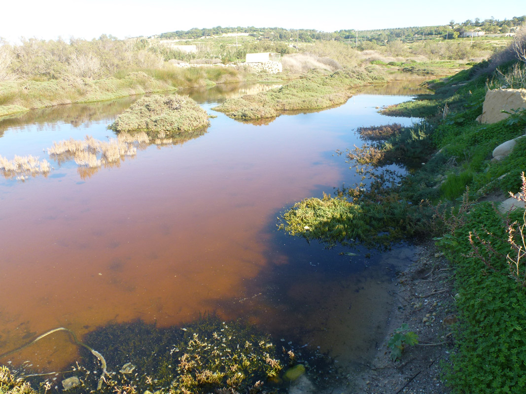
The Special Area of Conservation (SAC) of Il-Ballut ta' Marsaxlokk is found within the Marsaxlokk locality boundary in the south east of Malta and is within the north-east corner of Marsaxlokk Bay. The site is also protected as a Bird Sanctuary, Area of Ecological Importance and a Site of Scientific Importance. The area is located between the Marsaxlokk settlement and approximately 250 m from the Delimara power station. To the north of the site there is the Tas-Silġ hill. Il-Ballut saline marshland (coastal wetland) is located immediately adjacent to Il-Magħluq ta’ Marsaxlokk, a man-made enclosure for fishermen’s vessels. The area east of the site is predominantly used for agricultural activities. The main hydrological features are the lagoons or water pools. These water pools are desiccated during the dry season except for two pools. During the wet season the water pools overflow to fill a large extent of the saline marshland. Hypersaline conditions have been recorded during the dry season reaching a maximum of 71 X 10-3μscm-1. During the wet season salinity levels were much lower (55X 10-1μscm-1) and approached the levels of freshwater. The pH varied from 92 to 72 (Nature Trust, 2005 citing Bonello, 1992). The Il-Ballut marshland is designated as transitional water (MT203) under the Water Framework Directive 2000/60/EC. The backshore of the Il-Ballut marshland is a sloping topography from the Tas-Silġ area. A watercourse meanders down from the Tas-Silġ area in the direction of the marshland. Il-Ballut ta’ Marsaxlokk is part of a 0.68 km2 hydrological catchment. This catchment is of high significance to the SAC. In the past (during the 1990s) there was a problem of illegal sewage infiltration from farm effluent (personal communication, Vincent Attard, 2012). The contaminated water passed beneath Triq il-Power Station into the saline marshland. This issue has now been resolved since the farm is no longer operational. The habitats of importance in this SAC (listed in the Habitats Directive under Annex I) include: • Salicornia (Twiggy Glasswort) and other annuals (plants that complete their life cycle within one year) colonising mud and sand (Habitat 1310); • Mediterranean salt meadows (subject to flooding by sea water) (Habitat 1410); and • Mediterranean and thermo-Atlantic halophilous scrubs (perennial vegetation of marine saline muds) (Habitat 1420). Although no Annex II species have been noted at the site, a number of invertebrate species listed in the Red Data Book (RDB) have been recorded on site that are of conservation importance. Several threats exert pressure on the ecology of the site. There is evidence that coastal erosion could be a threat to maintaining the saltmarsh in its current state. Erosion has resulted in damage to the surrounding fence and some areas with vegetation are now also in direct contact with the sea. Two major point activities operating outside the site and possibly affecting it are identified. These are the Power Station located to the east of the site and the Marsaxlokk marina adjacent to the site. Other threats to the site include motorbikes off-roading/scrambling within the site, and in general people can access the site unrestricted. The site is also subject to dumping, and litter and waste accumulate at the site that are most likely washed ashore by the sea. Noise and light pollution may be a limiting factor to wildlife, given the small size of the site and the urbanised surroundings. Runoff from the fields east of the saltmarsh reaches the habitat from underneath the road. Impacts from pesticides could affect the saltmarsh communities and fertilisers in the run-off may affect the water quality in the coastal lagoons. A gutter also lies parallel to the edge of the site adjacent to the road. A culvert lies along the western border of the habitat that connects with the sea. The aim of the culvert is to prevent flooding in neighbouring fields from the area in case of heavy rain and at the same time allow a link with the sea, however, the culvert is not currently operating as planned and a connection with the sea is not consistent. The saltmarsh habitats may be vulnerable to invasion by alien species such as the Castor Oil Tree. Non typical marshland species are also established. There is evidence of hunting activities taking place within the protected area. Hunting within the saltmarsh could result in negative impacts on the vegetation communities and impacts on birds using the area.

Wetland data
Basic information
| Wetland location: | Marine/Coastal |
| Wetland type: | Natural |
| Wetland area: | 1.10 Ha |
| Hydrological interaction: | - |
| Water salinity: | Brackish (5.0-18.0 g/l) |
| Type of fresh water input: | Catchment area (precipitation) |
| Surface water runoff | Other |
| Open water area (%): | 5 - 25 |
| Hydroperiod: | Permanent |
Geographic information
| Census district: | South Eastern |
| Island: | Malta |
| Local council: | Marsaxlokk |
| Longitude: | 14.549140 East |
| Latitude: | 35.839000 North |
Wetland condition
| Wetland status (MEDWET): | 3 - Original habitats/landform partially modified (10-50% untouched) |
Ramsar wetland type
| Type | Coverage (%) |
| H -- Intertidal marshes; includes salt marshes, salt meadows, saltings, raised salt marshes; includes tidal brackish and freshwater marshes |
Property status
| Public |
| Protection status category | Protection status subcategory | Area's name | Code | Coverage area (%) | Legislation |
| International | Special Areas of Conservation - International Importance | Il-Ballut (l/ta' Marsaxlokk) | 100 | Environment Protection Act (Act I of 2016) | |
| International | Transitional Waters (WFD) | Il-Ballut ta' Marsaxlokk | 100 | Water Framework Directive | |
| National | Bird Sanctuary | Il-madwar tal-bur salmastru f' Tal-Ballut, Marsaxlokk | 100 | Environment Protection Act (Act I of 2016) | |
| National | Area of Ecological Importance/Site of Scientific Importance | Il-Maghluq, limiti ta' Marsaxlokk | 100 | Development Planning Act (Act VII of 2016) |
CDDA protection status
| CDDA code | CDDA category |
| MT03 | Bird Sanctuary |
| MT11 | Special Areas of Conservation - International Importance |
| MT02 | Area of Ecological Importance/Site of Scientific Importance |
Ecosystem services
| Type of ecosystem service | Ecosystem service | Scale of Βenefit (%) | Importance |
| Cultural services | Cultural heritage | ||
| Supporting services | Provision of habitat | ||
| Regulatory services | Water regulation |
Activities on wetland
| Activity | Intensity |
| 010 = Habitat conservation | High |
| 030 = Species conservation | Medium |
| 701 = water pollution | High |
| 790 = Other pollution/human impacts/activities | Low |
Activities on catchment area
| Activity | Intensity |
| 100 = Cultivation | High |
| 110 = Use of pesticides | High |
| 120 = Fertilisation | High |
| 130 = Irrigation | High |
| 402 = discontinuous urbanisation | Low |
| 430 = Agricultural structures | Low |
| 502 = roads motorways | Medium |
| 701 = water pollution | High |
| 790 = Other pollution/human impacts/activities | Medium |
Impacts
| Impact | Intensity |
| ED- = Increase in sediment removal/retention | High |
| EF- = Increase in protection from natural forces | Medium |
| PF- = Fertilizer/Excess nutrient pollution | High |
| PP- = Pesticide pollution | Low |
Vegetation types
| Type | Coverage (%) |
| Halophytic | 51 - 75 |
| Emergent | < 5 |
| Ammophilous | |
| Other | |
| Wet meadow | 5 - 25 |
Flora
| Species | Presence status | References |
| Arthrocnemum macrostachyum | ||
| Cakile maritima | ||
| Carex extensa | ||
| Halimione portulacoides | ||
| Jacobaea crithmoides | ||
| Limonium virgatum | ||
| Matthiola tricuspidata | ||
| Pancratium maritimum | ||
| Phragmites australis | ||
| Ricinus communis | ||
| Salicornia ramosissima | ||
| Salsola kali | ||
| Suaeda vera |
Fauna
Invertebrates |
Presence status in wetland |
References |
|
| Brachygluta globulicollis aubei | |||
| Brachygluta simplex hipponensis | |||
| Stenosis melitana (Reitter, 1894) | |||
| Hydrobia acuta (Draparnaud, 1805) |
Nature Trust Malta (2005) Il-Ballut Nature Reserve, Marsaxlokk: Management Plan for the years 2006-2010
Henwood, J., Falzon, A., Bonello, A., Attard, V., Bonavia, O. (2005) Il-Ballut Nature Reserve, Marsaxlokk: Management Plan for the years 2006-2010. Nature Trust (Malta).
Falzon, A. (1999) An evaluation of the vegetational changes at the nature reserve of il-Ballut saline marshland (Marsaxlokk).International Environmental Institute, Universityof Malta.
ERA (2015) The 2 nd Water Catchment Management Plan for the Malta Water Catchment District 2015 - 2021
Bonello, A. (1992) Vegetational and other changes at il-Ballut saline marshland: A nature reserve in the making (Unpublished B.Sc. dissertation). Faculty of Science, University of Malta.
Bonanno, G., Borg, J. & di Martino, V. (2017) Levels of heavy metals in wetland and marine vascular plants and their biomonitoring potential : a comparative assessment
Adi Epsilon Consortium (2014e) Il-Ballut ta’ Marsaxlokk – Natura 2000 Management Plan (SAC). Prepared for the Malta Environment and Planning Authority under CT3101/2011. San Gwann, Malta, pp. 112 + Annex
Images